

Subscribe for Project Updates

The Colma Creek Flood Zone was established with the boundary of the Colma Creek Watershed. This is one of four long-standing active flood zones that OneShoreline inherited from the former San Mateo County Flood Control District. Through the Flood Zone OneShoreline coordinates and facilitates management around the Creek.
Table of Contents
Background
All land is part of a watershed, and all individual watersheds are defined by rain. A watershed is an area of land that drains rain to a common body of water. This relationship is connected with the shape of land and the wellbeing of the natural and human communities that live there.
The Colma Creek Watershed spans approximately 16.6 square miles across San Bruno Mountain to Daly City, South San Francisco, Colma, Pacifica, and San Bruno down to the San Francisco Bay estuary. This region is a recognized part of the ancestral lands of the Ramaytush Ohlone. Characterized by steep coastal headwaters, urban areas, and tidal influence near the Bay, Colma Creek presents complex challenges for flood management and coastal resilience.
Originally established in 1964, the Flood Zone was created to manage flooding and has undergone significant infrastructure development over the decades.
- 1964–1978: Concrete channel walls were constructed, with a soft-bottom section between Utah Avenue and Produce Avenue. Bridges and channel walls were also built in this period, except for the Airport Boulevard bridge, which was reconstructed in 2002.
- 2006: A rectangular concrete channel was constructed between Produce Avenue and San Mateo Avenue, in addition to the raising of the San Mateo Avenue bridge.
Colma Creek’s existing flood management facilities were designed for previous weather patterns and conditions. As storms increase in intensity, duration, and frequency due to climate change, along with substantial growth and redevelopment, this flood control infrastructure requires significant reassessments and upgrades.
In addition, Colma Creek and adjacent Bay wetlands are critical ecological resources and present opportunities for better supporting community wellbeing. Improving habitat can increase species diversity and abundance, while also improving water and air quality. Expanded open spaces and amenities can also provide greater access to nature, outdoor activity, and active transportation including walking and biking, and a more accessible Bay Trail.
Project Overview
There are currently two projects in the Colma Creek Flood Zone. The shared objectives for ongoing work are:
Flood resilience: reduce flood risk and create long-term resilience to climate change
Water quality: improve water quality
Ecology: restore and enhance native species habitat and strive to connect diverse and abundant ecosystems
Public access and safety: connect Colma Creek to surrounding communities
Economic development: leverage investments to transform Colma Creek into a regional amenity
Both projects build on the many previous studies that have explored opportunities and potential solutions for this area, including incorporating feedback heard from the community since 2018.
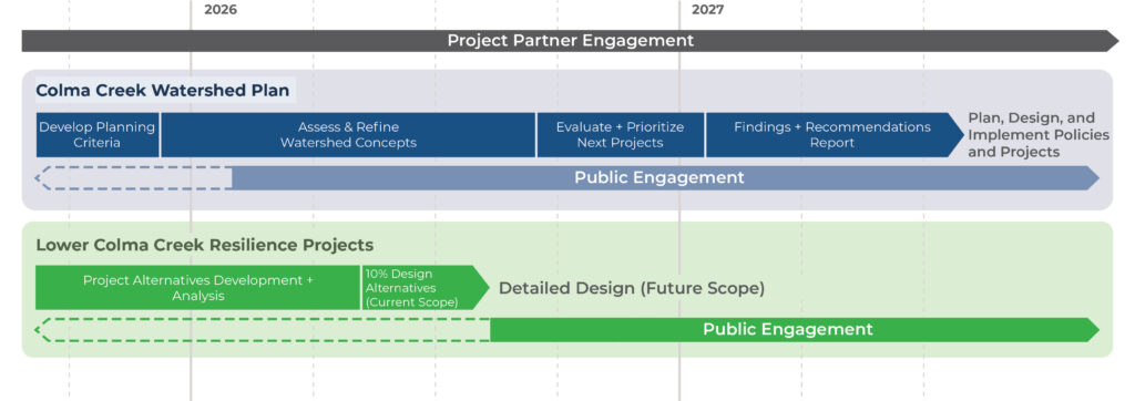
Colma Creek Watershed Plan
The Colma Creek Watershed Plan will serve as a blueprint to transform Colma Creek into a vital community asset nourished by a healthy watershed. The Watershed Plan will build on local plans and studies while advancing new strategies to address the pressing challenges of flooding and sea level rise.
The work will identify and prioritize projects, programs, and policies that improve public health and safety, enhance habitat, improve water quality and supply, and expand public access and connection to the Creek, advancing ideas and priorities expressed by community members that result in actions that reflect regional needs and local aspirations.
Lower Colma Creek Resilience Projects
The Lower Colma Creek Resilience Projects will reduce sea level rise and flooding risks, improve public safety, and expand public access along Colma Creek from San Mateo Avenue to Utah Avenue in South San Francisco.
Infrastructure resilience planning will prioritize changes that improve flood management, support native species habitat, improve water quality, and provide opportunities for surrounding communities to recreate and connect with the Creek.
Project Timeline
Project updates will be added to the individual project pages as they become available.
Opportunities for Feedback
OneShoreline is committed to transparent and meaningful engagement with project partners and the community. OneShoreline facilitates a Colma Creek Citizens Advisory Committee (CCCAC), in addition to communication through meetings with government and community partners, a technical working group, public events, and project-specific efforts.
CCCAC meetings are convened on a quarterly basis, and members of the public are welcome to attend. See here for the full list of members and agendas and minutes of past CCCAC meetings for more details.
Public Engagement
Opportunities to provide feedback on both projects will be available in 2026 and beyond. Sign up below to receive updates.
Subscribe for Project Updates


