
Pillar Point Harbor and the surrounding northern Half Moon Bay coastline is a recreation epicenter on the San Mateo County coast for both local and non-local outdoor enthusiasts. The shoreline trails and beaches in this area are used by a diverse cross-section of community residents for kayaking, coastal access, walking, and bird watching. Key destinations include the iconic Mavericks surfing location that attracts big-wave surfers from around the world, Surfers Beach, and Miramar Beach in Half Moon Bay. Significant coastal access corridors – State Route 1 and the California Coastal Trail – back these beaches. In addition, this reach of coastline is home to important ecological assets, including Pillar Point Marsh, which serves as habitat for threatened species and species of concern. Bird enthusiasts have sighted nearly 20% of all North American bird species in this 66-acre protected salt marsh.
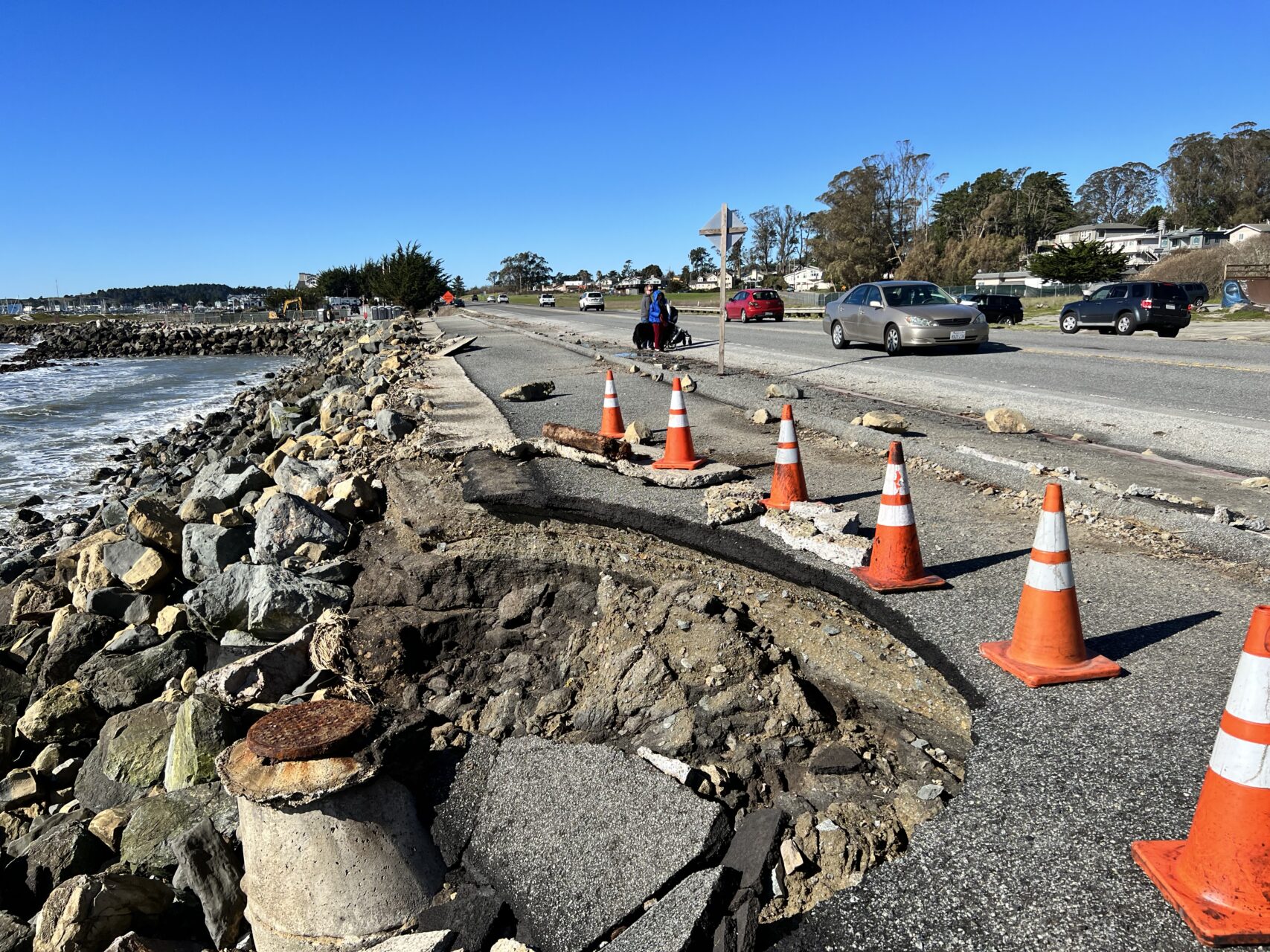
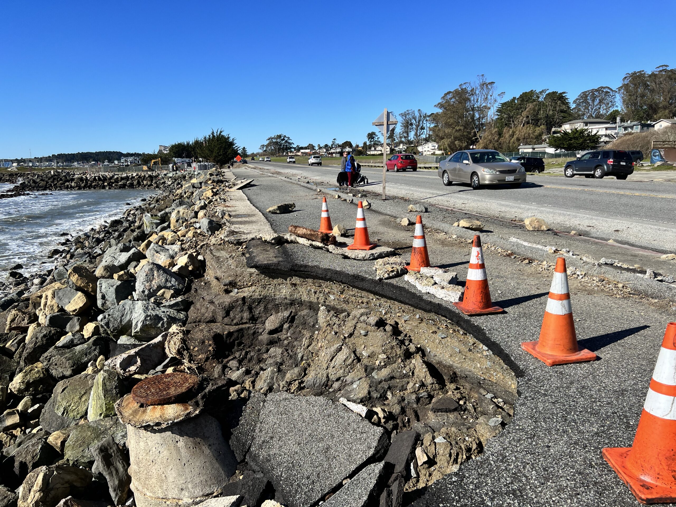
This region faces serious ongoing coastal erosion issues, dating back to the construction of breakwaters in the early 1960s by the U.S. Army Corps of Engineers to protect Pillar Point Harbor and community of Princeton-by-the-Sea (Princeton). Following the construction of the outer breakwaters, rates of coastal erosion both within the Harbor and along the shoreline directly south of the east breakwater dramatically increased, retreating at a rate over 7 times greater than the rate of erosion before the breakwater in some areas of the Princeton shoreline. The evolution from a smooth, continuous sandy coastline to an eroded bluff or hardened shoreline can be clearly seen in historical aerial photography.


Current rates of erosion will likely be exacerbated with sea level rise and climate-driven storms. The 2018 San Mateo County Sea Level Rise Vulnerability Assessment found that State Route 1 at Surfer’s Beach, as well as Mirada Road to the south, are compromised and extremely vulnerable to sea level rise. In addition, vulnerable unincorporated communities such as Princeton face critical flooding threats, with one-third of its population and land area projected to be inundated during a 100-year event and six feet of sea level rise.
A series of past and ongoing projects have been developed to address these issues on certain shoreline reaches. From 2010 to 2016, the U.S. Army Corps of Engineers prepared several documents and studies to determine the feasibility of a project to mitigate the impacts of the Pillar Point Harbor breakwaters, including renourishment of Surfers Beach, and ultimately concluded that such a project does not have a federal interest. More recently, the San Mateo County Harbor District has led the West Trail Living Shoreline Project to stabilize the popular recreational trial that serves as access to Mavericks Beach and the harbor’s west breakwater. The Harbor District is also implementing the Surfers Beach Restoration Pilot Project, which involves a one-time placement of sand that been trapped inside the breakwaters. Meanwhile, San Mateo County is leading an effort to update land use policies to provide a sustainable direction for future development along the Princeton shoreline (Plan Princeton), and has also evaluated solutions to stabilize Mirada Road and the Mirada Road pedestrian bridge. While various project-specific studies have recognized the erosion concerns in this area due to the breakwaters, no comprehensive erosion modeling has been performed in and around the harbor, and no meaningful progress can proceed without this baseline understanding of current conditions.
In 2021, OneShoreline embarked on a study to define a comprehensive shoreline management approach that takes a holistic look at this complex landscape in two ways:
- In terms of geography, the current project scope looks at the northern Half Moon Bay shoreline from Mavericks Beach to the Mirada Road bridge.
- In terms of time scale, this work is focused on addressing the impacts of coastal erosion and sea level rise in the long-term: to protect the community from the current FEMA 100-year floodplain plus approximately 6 feet of sea level rise, taking in account accelerating shoreline erosion rates.
OneShoreline engaged a consultant team to leverage the information gathered from past efforts and define alternatives in the context of these holistic objectives. The daunting extent of these impacts demands a bold approach that keeps all options on the table, and while all alternatives will be considered at the initial planning stages, nature-based solutions are preferred. The findings of this study was presented to the San Mateo County Harbor District Board of Commissioners on May 17, 2023.