Constructing the $8.6 million Bayfront Canal-Atherton Channel Project to protect people and property from frequent flooding

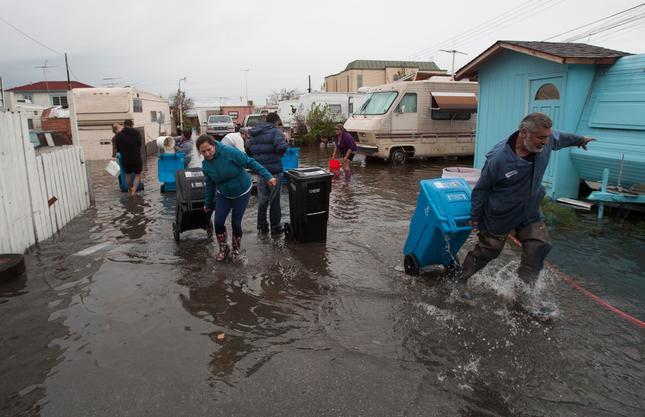
Atherton Channel converges with the Bayfront Canal near the border between Redwood City and Menlo Park, and empties into San Francisco Bay through a tide control structure not far from Bedwell Bayfront Park. For the past several decades, even minor rainfall events that coincide with a high tide caused water in the Channel and Canal to back up and flood mobile home parks and businesses in the area.

Residents at the Le Mar Trailer Park in Redwood City during December 2014 flooding
(John Green/Bay Area News Group)

In response to this proven threat, the District is leading a project that partners with Redwood City, Menlo Park, Atherton, and San Mateo County, with over $1.1 million in support from the State, to install an underground culvert to divert stormwater into former salt ponds owned by the U.S. Fish & Wildlife Service. This project’s new outlet for high flows during high tides will reduce the frequency and amount of flooding, thereby reducing costs and improving public health and safety, and its new trash capture device will improve water quality in the Bay. The public agencies partnering on this project intend for it to be the first of several within this 5,500 acre watershed. In a related effort as part of a countywide early warning system, the District is installing a device to monitor streamflow in Atherton Channel at the Caltrain tracks in order to provide advance notification of potential flooding downstream to the public and emergency responders.

Throughout October, the agreement to secure $8.6 million for the project’s construction, operations, maintenance, and mitigation, and agreements for necessary easements, will be discussed at meetings of the governing bodies of the partner agencies, with the goal of beginning construction in early 2021.

Keep up to date on this effort on our project webpage.

Transforming flood-prone liabilities into community assets: How the District’s new approach is taking shape along Colma Creek

Upon its formation earlier this year, the District inherited from San Mateo County four long-standing flood zones, including one throughout the approximately 10,000 acre Colma Creek watershed. Since 1959, the objective of these property tax-collecting areas had been to control flooding, and for Colma Creek, this was largely achieved up to a 50-year storm event (on the commonly used 100-year scale that is the basis for FEMA’s flood insurance maps) by lining the channel with concrete and building floodwalls.

Upon taking over management of the flood zones this year, the District has expanded the objectives for these zones. Our new approach recognizes the increased flood threat brought on by climate change and the transformative mindset such a threat demands. Going forward, the District will manage and pursue projects that seek to enhance community resilience by taking a more holistic approach to:

  • The threats we face, by considering the risks caused by sea level rise and more extreme storms;
  • Our objectives, by reducing those threats and turning waterways and shorelines into environmental and recreational assets that are integrated into communities; and
  • Geography, by acting beyond city boundaries to lead a coordinated approach among all jurisdictions in the watershed or regional shoreline.

Thus, in addition to protecting against major storms and sea level rise, the District is pursuing nature-based solutions; seeking partnerships with private and public landowners to achieve mutual objectives; enhancing aesthetics, and community gathering and recreational spaces; and connecting creek and shoreline improvements to a city’s goals for the area.

This new approach has already begun to take shape in efforts along Colma Creek. The District is currently working with local partners to ensure that a floodwall project at and downstream of Utah Avenue preserves opportunities for bike and pedestrian trail access to upstream areas. We are also coordinating with a private developer and city to restore the creek to a more natural state as part of that development. The District looks forward to further collaborating with local partners and stakeholders in advancing this shared vision.

Keep up to date on efforts in this area on our project webpage.