
Table of Contents
Project Background
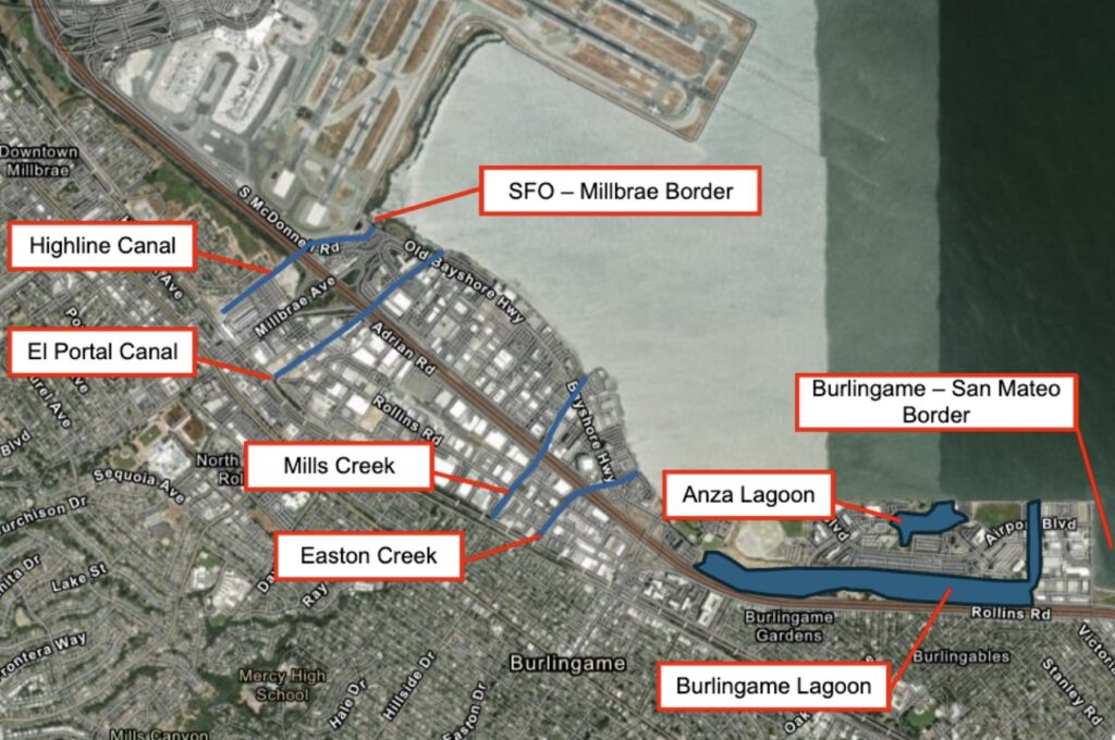
The cities of Millbrae and Burlingame are located along San Mateo County’s Bay shoreline, which is characterized by low-lying, heavily developed lands and limited space for shoreline protection, public access, and habitat infrastructure. The San Francisco International Airport (SFO) is located immediately north of Millbrae, with Burlingame located directly south of Millbrae.

This area of the Bay shoreline presents several complex and interrelated constraints that make the Millbrae and Burlingame Shoreline Resilience Project (MBSRP) a cornerstone initiative for OneShoreline and for the region. These constraints include limited space due to existing development; balancing regulatory requirements that prioritize nature-based approaches while limiting new Bay fill; managing flows during increasingly extreme storms and tides in multiple creeks and lagoons that drain to the Bay; meeting FEMA-accredited flood protection standards; and avoiding any increase in wildlife hazards to aircraft operating at SFO.
Two types of flood hazards threaten this project area:
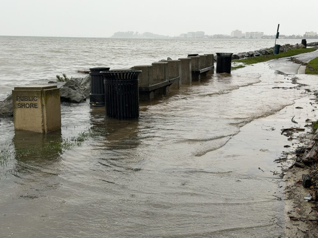
- Shoreline flooding from San Francisco Bay resulting from storm surges and high tides, which are increasing with sea level rise.
- Inland flooding during major rainfall events that overwhelm local creeks and storm drain systems and are exacerbated by high tides.
Flood Hazard Impacts
The project area includes heavily developed areas with regionally significant infrastructure, including San Francisco International Airport, two water treatment plants, U.S. Highway 101, a major rail corridor and intermodal transportation center, parks, hotels, restaurants, research and development enterprises, and other businesses that are vital to the current and future prosperity of Millbrae, Burlingame, and the broader Bay Area.
Without coordinated, long-term shoreline resilience measures, these assets face increasing flood risk from sea level rise and extreme storms, with consequences that extend well beyond the immediate project area.
Public Access and Recreation
The quality and quantity of access opportunities to and along the Bay shoreline in the project area are lacking. Where segments of the San Francisco Bay Trail exist, there are sections of unsafe and degraded trail conditions, which will likely face increased degradation with sea level rise. In addition, there are multiple critical gaps in the Bay Trail throughout the project area that limit shoreline connectivity and public access.
Habitat
Historically, much of the project area consisted of tidal flats, tidal marshes, and shellfish habitats. Over time, as land was created using Bay fill to support development and infrastructure, much of this habitat was lost. Today, only limited tidal flats, marsh areas, and shell hash pocket beaches remain.
With continued sea level rise, these remaining habitats face conversion to open water without targeted intervention, underscoring the urgency of a coordinated shoreline resilience strategy that considers both environmental conditions and site-specific constraints, including proximity to airport operations.
Regional Planning Context
In late 2019 and in early 2020, separate studies by Burlingame and Millbrae evaluated alternatives to build resilience to current and future climate-driven hazards along the shoreline. Meanwhile, SFO is planning and designing a Shoreline Protection Program to protect the entire perimeter of the airport from sea level rise.
As the most vulnerable county in California to sea level rise, San Mateo County requires a coordinated, long-term shoreline resilience strategy that links and leverages efforts across jurisdictions. The San Mateo County Flood and Sea Level Rise Resiliency District (OneShoreline) was established by State legislation in 2020 to support these independent efforts in a coordinated and connected way and to advance regionally aligned shoreline protection systems.
Project Overview
Project Goal
The Millbrae and Burlingame Shoreline Resilience Project (MBSRP) will provide long-term climate resilience against sea level rise and extreme storms for developed, natural, and public access areas along the Millbrae and Burlingame Bay shoreline.
Project Objectives
The project’s goal is to provide long-term climate resilience against sea level rise and extreme storms for developed, natural, and public access areas, with the following specific objectives:
- Shoreline Flood Protection: Protect communities, infrastructure, and habitats in Millbrae and Burlingame from current flooding made worse by future sea level rise.
- Public Access and Recreation: Enhance the Bay shoreline experience today and in the future through the completion and improvement of the Bay Trail and connections to it, and increasing access to other forms of recreation, for members of the community.
- Sustainable Ecosystems: Facilitate healthy, sustainable ecosystems, in the context of concerns about increasing attractants for birds that are incompatible with airport operations.
Additional objectives are to:
- Connect with existing and planned coastal resilience efforts to the north and south to support a continuous, multi-jurisdictional flood protection system.
- Consistent with the Millbrae and Burlingame zoning ordinances, integrate with and leverage redevelopment projects within the project site to promote shared responsibility for community resilience, consistent design standards, minimize environmental impacts, streamline permitting, and reduce mitigation costs.
- Incorporate Bay Conservation and Development Commission (BCDC) Regional Shoreline Adaption Plan (RSAP) coastal flood hazard scenarios and adaptation strategy standards into the project design.
Project Constraints
There are multiple project constraints that affect feasible options for design, including:
- Heavily Urbanized Shoreline Area: Existing and recently permitted developments along the Bay shoreline in the project area significantly limit the space available for the project.
- Creeks and Lagoons: Four creeks and two lagoons drain to the shoreline in the project area, requiring any project alternative to meet two conflicting objectives to prevent flooding: 1) keep high Bay water levels from travelling up these waterbodies and 2) also allow upstream drainage to remain effective.
- FEMA Accreditation: The project must meet requirements to be accredited by FEMA so that areas on the landward side of the infrastructure are not mandated to purchase flood insurance, and therefore must incorporate coastal flood protection recognized by FEMA (gravity seawalls, pile-supported seawalls, anchored bulkheads, and dikes/levees).
- No net increase in hazardous wildlife attractants: The project should not increase the risk of attracting high-flying birds, which may pose a safety hazard to aircraft and passengers that are taking off or landing at SFO.
Project Opportunities
This project is a marquee project for OneShoreline that will provide long-term resilience for a key reach of San Mateo County’s Bay shoreline, leverage the resilience planning of neighbors to the north (SFO) and south (City of San Mateo), and incorporate ecological, recreation, connectivity, and community enhancements. Since it is OneShoreline’s first regional sea level rise project, it provides the opportunity to innovate and incorporate a more holistic approach to flood protection that can serve as a model for the many areas with similar challenges across the Bay Area and California.
Project Funding
The planning and design phase of this project is funded by the State through the California State Coastal Conservancy and federal grant programs.
Project Alternatives
Three draft alternatives were presented to the public in fall 2024. Public and partner feedback was collected and evaluated through the end of the year. A summary of public engagement is available here.
Alternatives Development and Refinement
Throughout 2025, the project team conducted a reach-by-reach and parcel-by-parcel assessment of feasible shoreline protection measures, considering constructability, spatial limitations, ecological opportunities, flood protection benefits, property constraints, and compatibility with SFO safety requirements.
Several concepts that were considered earlier in the planning process, including offshore or nearshore tidal barriers with lagoons, subsurface or “tunnel” flood protection features, large pump stations, and broad horizontal levees, were evaluated and are no longer being advanced. These concepts were removed from further consideration due to technical infeasibility, regulatory challenges related to Bay fill, constructability limitations, and/or conflicts with Federal Aviation Administration (FAA) wildlife hazard guidance.
Removing these concepts allowed the project team to focus on approaches that better balance flood protection, environmental considerations, public access, and aviation safety within the project area’s significant constraints.
Current Project Approach
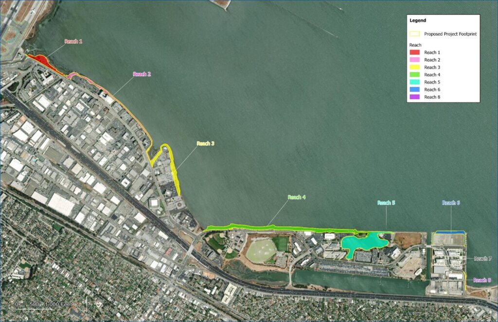
The current concept being analyzed in the environmental review process would prioritize primarily onshore flood protection, implemented where redevelopment or site conditions allow. The proposed approach would include multipurpose levees designed to provide rocky intertidal benefits, raised park areas such as Bayfront Park, seawalls and floodwalls in areas constrained by airport operations or existing aquatic habitat, engineered structures called groynes to support sediment retention and shoreline stability, and tide gates. This concept represents one of several approaches evaluated to date; a broad range of flood protection and adaptation alternatives has been considered, and additional alternatives will be analyzed and compared in the Environmental Impact Report (EIR).
While different flood protection and habitat features would be proposed in different shoreline reaches, the project would aim to provide a uniform level of protection against sea level rise and extreme storms, along with a cohesive public experience. Public access improvements would enhance shoreline connectivity and recreation by upgrading and closing gaps in the Bay Trail and improving access to the shoreline, with a continuous, ADA-compliant Bay Trail, connections to adjacent streets and parks, select viewing areas and spur trails where feasible, and habitat-compatible landscaping designed to comply with SFO’s Wildlife Hazard Management Plan.
Implementation would likely occur in phases, reflecting funding availability, redevelopment timing, permitting requirements, environmental considerations, and coordination with partner agencies and affected landowners.
Next Steps
The proposed alternative will continue to be refined through ongoing coordination with regulatory agencies, community-based organizations, shoreline landowners, and other stakeholders, as well as through preparation of the Draft Environmental Impact Report (DEIR). The DEIR will evaluate the proposed alternative, compare it to reasonable alternatives, assess potential environmental impacts, and identify mitigation measures.
Outreach and engagement will continue throughout the environmental review process, with a goal of completing the DEIR in fall 2026. A series of workshops and meetings with Community Based Organizations is planned concurrent with the DEIR release.
Have a question or feedback? Email MBSRP@OneShoreline.org.
Project Timeline
Opportunities for Feedback on the Millbrae and Burlingame Shoreline Resilience Project
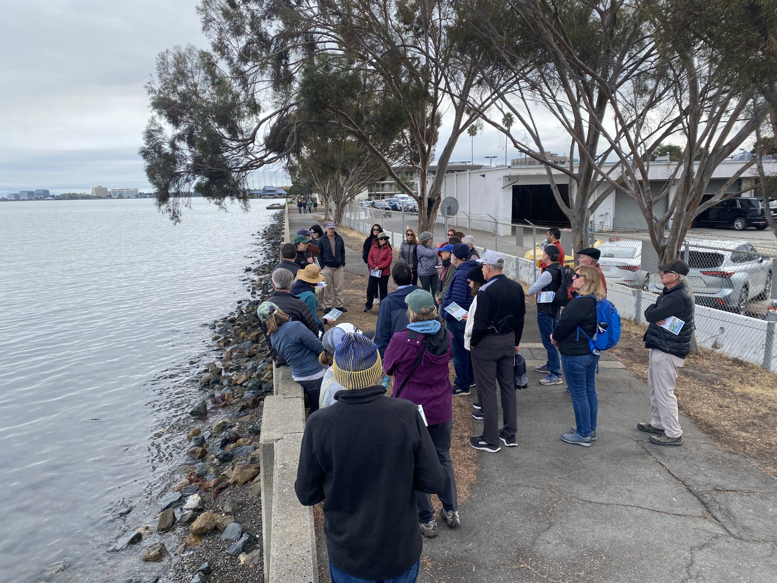
OneShoreline is committed to transparency and authentic engagement with its project partners and the community.
Upcoming engagement opportunities related to the project will be listed on this webpage as available, and we routinely update the Board on project progress. A public community meeting is anticipated concurrent with the lease of the Draft Environmental Impact REport.
Have a question or feedback? Email MBSRP@OneShoreline.org.
Sign-up for the project newsletter below to receive ongoing updates.